Severe Thunderstorms at Armidale NSW
© Compiled by Peter Burr. No part of the
following may be reproduced
for commercial purposes without prior permission from the author.
Severe hailstorms have become
more common in recent times. Armidale has been unlucky with four such storms
striking the city since 1996.
The first in September 1996 was the worst of the four with the largest
hailstones causing the most amount of damage. The entire city was affected.
The second storm in January 2000 had smaller hailstones, but widespread damage
to most of the city resulted.
The third storm in December 2006 affected only the eastern half of Armidale,
but severe damage occurred to this area.
After a break of eleven years another storm struck in November 2017 which was localised to North Armidale.
The severe thunderstorm in October 2021 not only produced hail, but also a
tornado which caused massive damage to parts of North Armidale.
Details of each event below.
29th September 1996
By lunch time the sky became
darker with storm clouds building in the west, and the familiar but ominous sound
of rumbling thunder was heard in the distance. A storm arrived just before
Then at
What was actually happening was
a huge cumulonimbus storm cloud or a supercell was building up about ten to
fifteen kilometres south-west of Armidale. Inside
this cloud massive updraughts were sweeping tiny
particles of dust and ice up into the higher reaches where supercooled
droplets of water were waiting to freeze onto them upon impact creating small
hailstones. These hailstones were then falling to the lower levels before again
being caught in the updraughts. After making many
trips up and down in the giant cloud the hailstones had become bigger than golf
balls too heavy to remain aloft, and started plummeting to the ground.
Unfortunately at this stage the storm cloud was approaching Armidale.
At 3.23pm the first of the
hailstones fell on the city. At this stage the stones were 10 to 20 mm in
diameter. They fell for about two minutes, then eased
briefly. A roaring sound was then heard across the valley from the south-west
as the main surge of hail approached. This was the sound of millions of large
hailstones hitting roofs. Then the huge hailstones started falling. They made a
deafening sound on roofs, and as they hit roads and hard surfaces they bounced
several metres back into the sky. The wind started
gusting from the south-west which was devastating for thousands of south and
west facing windows - the sound of breaking glass accompanied the roaring of
the hail. Then at 3.30pm it was all over. The black cloud rumbled its way to
the north-east as residents cautiously came out to survey the damage.
The scene that faced them was
one of smashed windows, dented cars with cracked windscreens, stripped gardens,
fallen branches, outdoor furniture destroyed, television antennas bent, and
everywhere on the ground thousands of golf ball-size chunks of ice. Some
hailstones where almost spherical, others jagged and irregular shaped.
Diameters of 30 to 50 millimetres were typical in the centre
of the city, but in other parts diameters of up 80 mm (cricket ball size) were
measured. Around 60 to 70 per cent of the ground was covered with hailstones,
some of which had become partly buried in the ground after hitting with
considerable force. In other parts of the city, particularly South Armidale
between the airport and South Hill the hail cover was 100 per cent with a depth
of 10 to 20 centimetres making driving hazardous.
Maximum wind gusts of 70 kilometres per hour in the centre of the city and 156 kilometres
per hour at the airport were recorded during the height of the storm.
As the extent of the damage
became apparent, the State Government declared Armidale a disaster zone. State
Emergency crews from as far as Coffs Harbour, Dorrigo
and Manilla were called in to assist local personnel. Over 1000 tarpaulins were
placed on leaking roofs, the children's ward at the hospital was evacuated as
water dripped through the ceiling, the historic Newling
Building (formerly Armidale Teacher's College) suffered severe damage to
windows, skylights and slate roof, and aircraft at the airport sustained
damage. Although the whole city was affected, parts of South and East Armidale
received the greatest damage.
It was later established that
about 80 per cent of buildings in the city, and in excess of 3000 vehicles had
suffered damage. The total cost was estimated to be close to 200 million
dollars.
Armidale was extremely unlucky
with this storm - the biggest hailstones fell mostly on the city itself while
nearby areas received little or no hail. Armidale averages 56 thunderstorms per
year with only seven per cent of these producing hail
of any size. In the 25 years prior to this event there had been only three
other severe storms with damaging hail - one in 1975 and two in 1994, but these
were minor compared to the 1996 storm.
It was considered to be a
"one in one hundred years event", and will go down in Armidale's history as the most destructive weather event in
the 20th Century.
The times quoted in this report refer to the centre of Armidale. Obviously these would have varied in
other parts of the city.
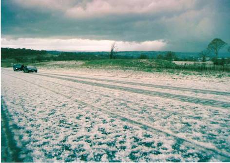
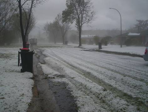
Top left: Looking north along the
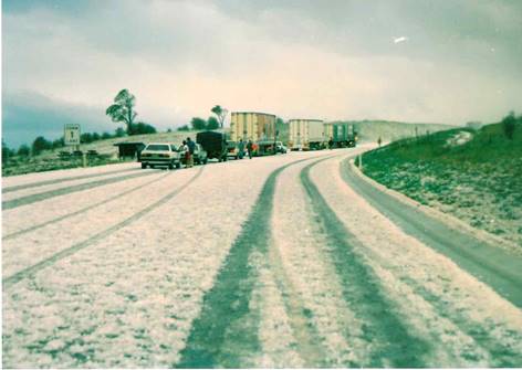
Top right: Traffic had ground to a halt
on the slippery ice-covered highway. This image looking south towards the
airport on the by-pass.
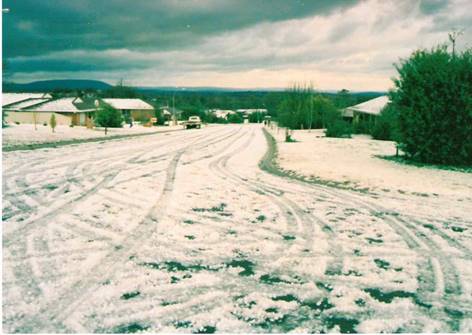
Above left:
Looking north down The Avenue in South Armidale.
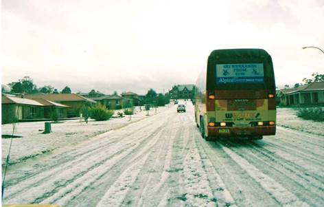
Above right: A
bus is having difficulty driving up The Avenue. All images by John Fields.
1st January 1st 2000
A spectacular start was made to the new year at
Armidale when a massive hailstorm swept through the city in the late afternoon
of the 1st of January 2000.
The huge thundercloud built up to the south-west of
the northern tablelands city from about
At 5.50pm rain started falling as the cloud moved in
from the south-west. Then the band of hail approached. It moved in quite slowly
preceded for several minutes by a roaring sound - the sound of hail hitting
distant roofs. This gave some residents, who recognised
the warning sound, time to place cars and other vulnerable items under cover.
At
The hailstones came in all sizes, the biggest measured
40 millimetres in diameter (golf ball size). Most were roughly spherical, only a few were
conglomerates of multiple stones fused together. The ground was completely
covered by the hailstones, several centimetres deep
in places, and large open areas of the city resembled snowfields. The ice
banked up deeply against south-facing walls and fences and much of it was still
there the next morning, not completely melting until around midday.
The hail affected the whole city as was well as some
surrounding areas. It appears to have started some 10 or 15 kilometres
to the south-west of Armidale and continued several kilometres
to the north, after lashing the city, before dissipating.
Rainfall including melted hail recorded in the hour
from 5.50 to 6.50pm was 26.8 millimetres which caused flash flooding in
Dumaresq Creek with water covering many of the causeways in the city. Very cold
air was swept in by the storm. The temperature dropped from 17 degrees at
Damage to the city included hundreds of destroyed
gardens, leaves and branches stripped from trees, cracked roof tiles, broken
skylights, smashed windows, and a large number of dented vehicles including new
and used cars at car yards. Many householders also suffered water leaking into
homes as a result of blocked and overflowing roof gutters.
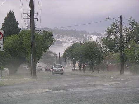
Photographs of this event are required. If you have
any of this hailstorm which could be used with this report please email them here.
21st December
2006
A severe hailstorm swept through central and East Armidale
in the afternoon of December 21st.
The storm moved in from the south just after
Widespread damage was caused in the form of broken
windows and skylights, felled trees, dented cars, damaged outdoor furniture,
and destroyed Christmas lights. The roof of the Livestock Exhibition Centre in Canambe Street completely collapsed under the weight of the
hail, and leaking roofs was another problem with many buildings due to
hail-clogged gutters. The strong winds also caused roof damage to some houses.
After the storm the area east of Marsh Street
resembled a winter snow scene, and due cooling of the air by the thick layer of
ice, a shallow fog developed and remained over the area for several hours.
Streets, footpaths and parks were strewn with a layer of branches and leaves
stripped from hundreds of trees and shrubs, and many gardens suffered total
destruction. The next morning large drifts of ice still remained on the ground
well into the day.
As the storm moved in the temperature plunged from 24
degrees at 2.45pm to just 11 degrees at 3.15pm. Rainfall at the
The day after the storm the state government declared
the storm affected area as a Natural Disaster Area.
Although most hailstones were no bigger than golf ball
size, there were some claims of isolated tennis ball size hailstones.
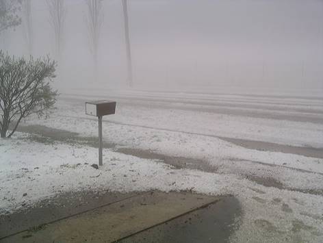
Top left: The
aftermath. North Street is covered with ice and leaves.
Top right:
Looking east down Erskine Street from the Faulkner Street intersection.
Note the white ice covered hill.
Above left: An
eerie mist developed over East Armidale after the storm passed as shown in this
Canambe Street view.
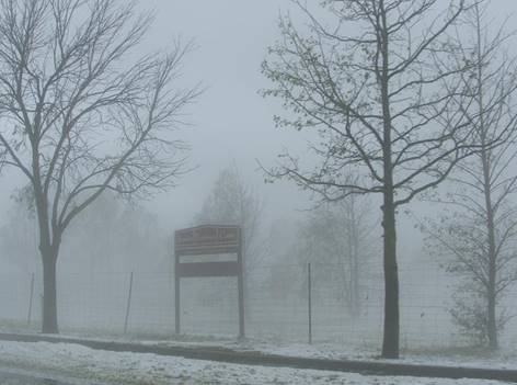
Above right:
The sign says: “Armidale Exhibition Centre”. The collapsed structure is
just out of sight to the left. These trees all had leaves on them an hour
earlier.
Images two and three by Maureen Heap.
6th November 2017
As a low pressure trough passed through New South Wales
a line of thunderstorms hundreds of kilometres long
developed over the west of the state and moved rapidly eastwards. As the storms
encountered uplift over the slopes and tablelands some of them became severe.
One such storm developed over Armidale at 4.20pm lasting for about 15 minutes
dropping large hailstones from one to three centimetres
in diameter with the northern parts of the city being worst affected.
Hailstones were smaller in central and southern parts. In north Armidale over
50 per cent of the ground was whitened by the hailstones which caused damage to
cars, gardens, trees and outdoor furniture. A total of 6.0 millimetres of rain
and melted hail was recorded at the city weather station from the storm with
higher amounts recorded in north Armidale.
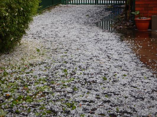
Above: Hail covered driveway in North Armidale shortly
after the storm finished.
14th October 2021 - Hail & Tornado
An active low pressure trough moved through
New South Wales generating thunderstorms over the eastern part of the state.
Severe storms developed in a number of areas including Armidale when a storm
passed over the city from the north-west between 9.30 and 10.30pm. The storm
produced heavy rain and hail from 9.50 to 10.10pm. Hailstones measured up to 25
mm diameter and whitened the ground.
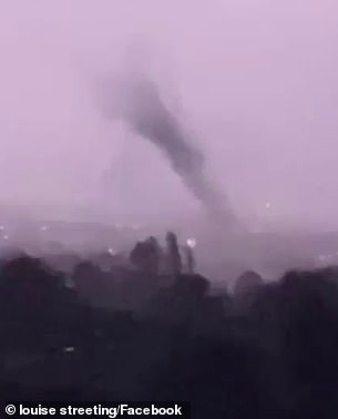
Between 10.10 and 10.15pm, as evidenced by several private weather stations and
phone video, a tornado passed across north Armidale moving rapidly in a
south-easterly direction. The tornado uprooted trees, damaged roofs, smashed
windows, power lines brought down, a car was overturned, and large amounts of
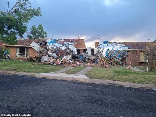
debris were lifted from the ground and scattered for some distance. Several
houses lost their entire roofs. This damage is consistent with an F1 tornado as
measured by the Fujita
Scale which means wind speeds in excess of 116 kms
per hour. Power was lost to hundreds of homes and not restored until the
following day. It appears the tornado developed about 15 kms
north-west of Armidale and headed on a south-easterly path towards Armidale
leaving an intermittent track of destruction to rural properties along the way.
Damage to trees east of Armidale along the Waterfall Way near Burying Ground
Creek indicates the tornado continued some kilometres east of the city before
finally dissipating.
Hail was fairly widespread across the city, while the tornado damage was
confined to a narrow track from the university across the north of Armidale to
eastern Erskine Street. Intermittent damage along this track indicates the base
of the tornado funnel lifted off the ground in some places.
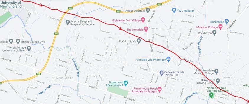
Approximate path of tornado shown below in red.
Return to Weather Home.